During the heyday of westerns, films showed cowboys riding through the Great Sonoran Desert from Arizona to what is now the State of Sonora in Mexico. The desert is still there and so are the cowboys.
Sonora is Mexico’s wild west. In some ways, it reflects the Old Mexico of the by-gone days of yesteryear. In others, it reflects the new Mexico-the Americanized Mexico of Wal-Mart and Sam’s Club, Pizza Hut and Burger King.
Beginning in Nogales on the Arizona border with the U.S., I decided to make a trek into an area of Mexico that’s often left off of the main tourist beat. The main roads through the State are well-marked and maintained due to Sonora’s almost fraternal bond with its northern neighbor, Arizona. Since I was already within the Sonoran Desert in Arizona, the landscape changed little as I crossed the border.
Unsuccessful early Spanish attempts to settle what’s now the state of Sonora left the area nearly invisible until the 17th and early 18th Centuries. But the discovery of gold in Alamos brought a steady stream of settlers from the south, and by 1824 the former province of Sonora y Sinaloa had become the State of Occidente. Eventually, the Mexican government divided Occidente into the States of Sonora and Sinaloa.
Luckily, at about the time the mines played out, agriculture in the Yaqui and Sonora River Valleys expanded to support the local economy together with fishing in the Sea of Cortez. Perhaps, it’s Sonora’s pioneering spirit that spawned three of Mexico’s presidents-Alvaro Obregon, Abelardo Rodriquz, the founder of the PRI party, and Plutarco Elias Calles.
But Sonora has always been the home of two very important indigenous tribes, the Yaqui and the Seri. While the Yaqui inhabited the valleys between present-day Guaymas and Sonora’s capital, Hermosillo, the Seri developed their culture amid the cactus along the coast above Guaymas.
As I drove south, I saw signs for some of missions founded by Jesuit missionaries, most of which stand near the border with Arizona. The missions encouraged the growth of haciendas, which became productive units and the social organization of the Sonoran countryside. During the 1880s, railroads helped spawn growth and by the 1920s, the Sierra had become the most prosperous region of Sonora due to the boom in mining, cattle and agriculture.
The Road to Hermosillo
The road to Hermosillo, the state capital, runs through the heart of the Sonoran Desert, more than two-thirds of which lies in Mexico. A young desert, it’s less than 10,000 years old. But it’s one of the most complex, due to the great variety of species and general structure of volcanic rocks sedimentary and metamorphic.
Subtropical deserts, such as this one, tend to have more plant species. Occasionally, I passed a cattle loading station, since Sonora is known for its fine beef, but not much else.
Tall Palo Verde “trees” dotted the landscape along with plants with names like creasote and Indigo bushes and mormon tea, and all forms of cacti-pencil cholla, barrel, Christmas and prickly pear cactus, as well as velvet mesquite. After a few hours of desert, I arrived in Hermosillo.
Hermosillo, Sonora’s capital, is a clean, well-planned town carved out of the rugged desert terrain. It’s set amidst sweeping plains of golden grasses and green-tufted hills with taller, serrated peaks rising abruptly in the background. This bustling city is the only town in Mexico in which all water is purified before it’s sent to homes.
Though the Spanish tried to impose a settlement called Santisima Trinidad del Pitic on the existing indigenous settlement called Pitic in 1700, confrontations with the Pima and Seri Indians forced them to wait nearly a century until they considered the area safe for habitation.
In 1828, the city’s name was changed to Hermosillo in honor of a general from Jalisco who was a hero in the war for independence from Spain.
A pleasant mix of modern Mexico and old Sonora, Hermosillo today is a common stopover for North American visitors, like myself, heading down the coast. It’s worth a stopover to enjoy downtown strolls along the laurel-lined avenues.
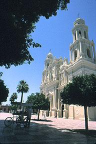
Plaza Zaragoza lies at the city’s heart. This spacious plaza, built in 1865, features a lofty, Florentine-style kiosk built in the early 1900s. At either end of the plaza are the Palacio de Gobierno and Catedral de Asuncion.
The Palacio de Gobierno, one of the most impressive government buildings of Northern Mexico, was originally constructed in the neoclassic style in 1859, using Yaqui labor and local stone. In 1881, Gov. Don Carlos Rodriguez had it rebuilt to serve as an institute of fine arts, but he was forced to leave office before his term ended. The next governor converted it into the Palacio de Gobierno in 1884. Unfortunately, it was almost completely destroyed in 1948 by fire.
The twin-towered cathedral with its striking white, tiered facade sits opposite the Palacio at the other end of the plaza. The original adobe chapel on this site, completed in 1778, had decayed so much by 1877 that 800 local women petitioned the Catholic diocese to have it replaced. The current neoclassical building was constructed in 1908 with a tall single bell tower. The sotuh tower was added in 1912. Between the two is a huge cupola, with tiered columns, niches, and arches, giving the effect of an elaborate wedding cake.
I thoroughly enjoyed exploring the Museo de Sonora, a 19th-century stone building that nce served as a state prison from 1907 to 1979. In 1985 the city converted it into a museum with exhibits on Sonora’s history, geology, natural history and anthropology.
About two dozen maquiladoras, assembly plants, call Hermosillo home. A well-trained workforce assembles everything from Ford cars to Barbie dolls in clean, ultramodern facilities set in fancifully designed industrial parks. But though industry has moved in, Hermosillo is still an agricultural center for wheat, cotton, soy, grapes and oranges.
After overnighting, I head west from Hermosillo along a modern four-lane highway for about an hour to the seaside resort of San Carlos.
By the Bay of San Carlos
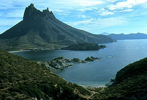
The names San Carlos, Bahia San Carlos, and San Carlos Bay, all refer to an area about seven miles northwest of Guaymas which includes Playa San Francisco, a long stretch of stony beach paralleling the coastal highway., the yacht harbor at Bahia San Carlos formed by two rocky peninsulas that jut into the Sea of Cortez, and the curving, sandy beach of Playa los Algodones on Bahia de Sonora. Backed by the 2,000-foot Sierra de Baccochibampo, the area is one of the most scenic along the coasts of Northern Mexico.
Mostly American retirees live in settlements that dot the cactus covered hills above the brilliant turquoise Bahia San Carlos. Prime real estate is available for sale and there are motels, hotels, RV Parks, condominiums and private home rentals to fit every group and budget. Prices start at $45/night or $450/month. While the resort has 2,000 year-round residents, the population swells as high as 6,000 during the peak tourist season.
The community hosts an 18-hole championship golf course, tennis courts, a bowling alley and numerous gift shops and galleries for shopping and browsing. For the boater, two marinas with 700 boat slips offer paved launch ramps, dry storage facilities, complete marine repair and maintenance services, fuel docks and reasonable rates for slip rental. San Carlos boasts numerous restaurants featuring seafood, Sonoran beef, Mexican dishes and American cuisine.
San Carlos offers one of the finest sailing venues in the Sea of Cortez. Magnificent mountain vistas, secluded coves and bays for anchoring out and deep water combined with complete marina services and storm safe anchorages make San Carlos a sailing paradise.
With more than 800 varieties of maritime species San Carlos ranks second in the world for sport fishing. During summer months, as the water temperatures rise, the exotic big game species are present, including marlin, sailfish, dorado (mahi-mahi) and tuna. From late fall into spring, there’s excellent bottom fishing for red snapper, sea trout, yellowtail, and sea bass in and around the many islands.
Diving is one of the most popular passions of visitors to San Carlos, whether you’re a first-timer or a veteran. Crystal clear and constantly calm waters, plus two artificial reefs, a sunken ferry and several smaller wrecks make the San Carlos an ideal place to learn and visit repeatedly.
As I sit on my balcony at the Howard Johnson San Carlos Plaza, I watch a pelican as it skims across the still morning water. The sky glows lavendar and pink. Suddenly, a small flock of cormorants appears, floating in unison on the surface of the water, disappearing to fish and again reappearing, repeating the process over and over. The warm air hugs the coast of the Bahia San Carlos where desert meets the sea. As the sun reaches ever higher, it shines strong, reflecting off still waters. Perhaps, I’ll head over to Playa Algodones, or “Cotton Beach,” as it’s known by the snowbirds, because of its fine white sand. Perhaps not.
After a couple of days soaking up the sun in San Carlos, I head down the autopista south of Guaymas. Stately Saguaros appear once again. The land is flat, rolling to the horizon covered with low scrub, mesquite trees and a few cacti. Cattle and horses graze randomly along the road to Cuidad Obregon. These are the Plains of Sonora stretching below Guaymas.
Yaqui Country
I drive through Yaqui country. Over 50,000 of them live in seven towns with names like Becum, Bacum and Belim. Ciudad Obregon lies at the entrance to the Yaqui Valley, a fertile farming region where man makes the desert bloom through drip irrigation.
Along the way, I stop to visit Tres Marias, a big-game ranch. Here five or six people can stay in the cozy rancho and hunt eight species of animals, including red and white-tailed deer and antelope, which are raised for hunting, Texas Dall Sheep, Wapiti elk, and pheasant, as well as mountain sheep, which roam over open ranges. All for $125 per day, including room, board, transfers, and beverages. I found out this is a big industry in Sonora.
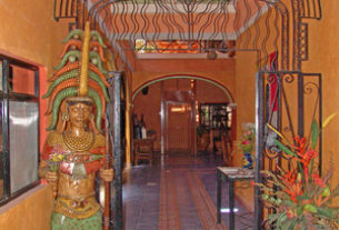
Leaving the big-game ranch, I follow the mountains past orange groves and mesquite into the wide open spaces on the way to Alamos. I arrive in the late afternoon about four hours later. Cowboys on horseback jockey for position with cars and 4x4s in the town’s narrow, cobblestoned streets. There’s a quaint peacefulness here that seems to be missing in Hermosillo and San Carlos. Maybe it’s the Old Mexico atmosphere of thick adobe walls and a clanging church bell.
The Charm of Alamos
Spanish conquistador Coronado visited this Sonoran colonial town set in the foothills of the Sierra Madre Occidental in 1531 but settlement didn’t occur until silver was discovered in 1663. It was originally named ‘Real de los Frailes” (Mining camp of the friars), referring to two nearby peaks that resemble monks.
At its peak, Alamos was the wealthiest town in Sonora-miners extracted over $500 million worth of silver from nearby mines over 200 years–and attracted immigrants from all over the Pacific, including a number of Chinese and Japanese, who founded a silk factory and were expelled in 1916 for having too much economic power.
The town prospered between 1750 and 1880. A series of rebellions by Yaqui mine laborers, followed by the 1910-20 revolution, brought all mining to a halt by the 1920s-the town quickly declined.
Today, Alamos has about 6,000 residents, many of them expatriate North Americans who have restored the charming Sonoran-style casas wrapped around interior courtyards in the center of town. But Alamos has managed to hold onto a traditional feel partially because of, rather than in spite of, the gringo presence. Around 250 Americans and Canadians have houses here but fewer than a dozen live here year-round.
I found the expat group in Alamos different from their San Carlos counterparts. Although most gringo homeowners reside only in winter, many take the time to learn Spanish and support the town’s cultural events.
I decided to go for a walk before dinner. Homeowners sweep the streets of Alamos’ cleaner than anywhere else in Mexico. Declared a National Historic Monument by the Mexican government, it has no billboards and no neon. Every sign or exterior renovation, in fact, must be approved as stylistically compatible before being displayed. Though the entire town can be seen on foot in less than two hours, I decided to hold off on a more in-depth exploration until the following day.
But for now, hunger drove me to Los Palermos, a cozy restaurant overlooking the Plaza de Armas. I sat outdoors under the portico and watched life on the plaza while I slowly savered a dish of molcajete stew, a mixture of chicken, onions, cheese, and green pepper boiled in a pot.
The following I began my tour of Alamos at the Plaza de Armas, a wide-open square crowned by an ornate, lacy wrought iron gazebo surrounded by an extensive rose garden rimmed with royal palms. Old houses, since converted into inns and restaurants, line its perimeter. At the far end stands La Parroquia de la Purisima Concepcion, a large stone church completed in 1786 after the Yaqui destroyed the adobe original in a 1772 uprising. At the opposite end is the compact Museo Costumbrista de Sonora, a small museum containing historic exhibits on Alamos mining, including a room plastered to look like a mine interior.
Adjacent to it stands Plaza Alameda a lovely square shaded by alamos (cottonwood) trees. The traditional evening promenade usually takes place here.
The City of Alamos is over three hundred and seventy years old and one of the best preserved. In the mid seventeen hundreds, King Carlos III of Spain sent a surveyor general to map out the city streets. Mansions were built by prospering silver barons.
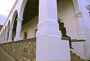
I found the many restored homes to be simple, imposing, block-like, single-story structures with grand entryways and tall, iron-grilled windows-at least from the outside. The most elaborate of them feature portales, sheltered walkways featuring Doric columns, topped with Roman arches. However, behind the facades, the houses follow a U-shaped or L-shaped plan around flower bedecked central courtyards. Since all of these houses are private residences, the only way to view them is to purchase an $8 ticket for the weekly House and Garden tours given each Saturday morning.
After soaking up the Old Mexico atmosphere Alamos, I headed over to Ciudad Obregon to drop my rental car and fly home.