Did You Know…?
Mexico’s equivalent of the Domesday book was compiled in the sixteenth century.
History shows that conquerors often have very little idea of what they have really acquired until it is firmly within their grasp. One of their first steps following victory is a comprehensive survey of everything of value, or potential value. For instance, in 1086, William the Conqueror ordered a survey of his newly acquired England, the results of which were compiled into the Domesday Book. The decision to send out his assessors to every corner of the land was made at his Christmas Court in 1085. As a belated Christmas present to himself, William wanted to know “what or how much each landholder had, in land or livestock, and how much money it was worth”, so that he could tax it accordingly.
Codex Mendoza Tribute Page
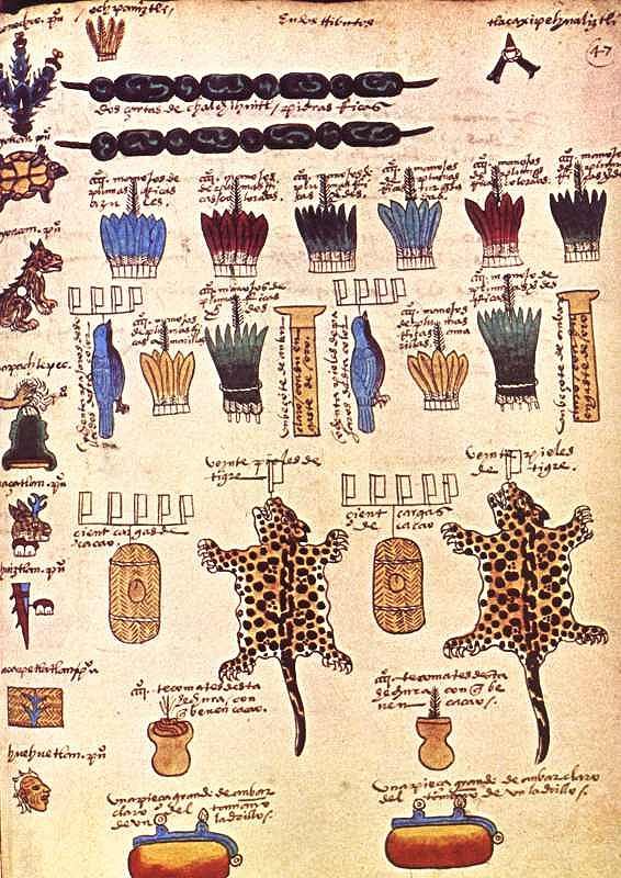
Though less comprehensive, a pictorial record of the wealth of Mexico already existed prior to the Spanish conquest. The Mexica people had gradually established an empire (the Aztec Empire) stretching from the Gulf coast to the Pacific. In order to administer the tributes due from each part of the empire, they recorded the requisite payments of feathers, animals, minerals and food, on bark paper codices, some of which still survive. (see image; click on image for enlarged picture with fuller explanation)
Such tribute lists were of little interest to the Spanish when they arrived. Some of the items held in high esteem by the Aztecs were deemed worthless by the conquerors. Other items, such as silver, of little or no consequence to the Aztecs, were highly prized by the Spaniards.
Back in Spain, the Spanish Court was determined to acquire accurate information about everything being encountered in New Spain. This led to a series of censuses and accounts, including the Relaciones geográficas (Geographic Accounts), the earliest version of which dates back to the late sixteenth century.
In 1569, shortly after Juan de Ovando y Godoy was named Visitor of the Council of the Indies, he sent a questionnaire containing 37 questions to the New World. Another questionnaire, with about 200 questions, was sent in 1570. A few years later, perhaps in an effort to elicit more responses from the provinces, Ovando y Godoy’s former secretary and successor Juan López de Velasco reduced the number of questions to 50. These 50 questions, sent to New Spain in 1577, became the basis for the Geographic Accounts.
The authorities in each administrative center were instructed to call a meeting of the “Spaniards and other natives in the district”, to find out everything they could about the area’s geography, people and history.
Of the 191 known responses to the 1577 questionnaire, 167 have survived in archives to the present day. Most of the original responses are housed in Spain, in either the Archivo General de las Indias (Seville) or the Real Academia de la Historia (Madrid). A further 43 of them form part of the Benson Latin American Collection in the University of Texas library in Austin. The library’s webpage about the Relaciones geográficas has several links to images of sample pages and maps.
The style and substance of a typical account can be judged by extracts of the response (dated 1579) from Xiquilpan [Jiquilpan], on present-day highway 15, south of Lake Chapala. Square brackets enclose editorial comments, not found in the original.
Xiquilpan is in temperate land… A river, which never dries up, passes the village; it carries very little water in summer. In winter, it often rises so much that it can not be crossed. Less than one league from this village towards the north is a lake called Chapala, which is forty leagues around. A lot of white fish and catfish, and another kind of small fish, are caught in it. A large, very full, river, called Chicnahuatengo, enters this lake. [One league is about the distance that could be walked in an hour, from 4.18 kilometers to 6.687 kilometers, depending on the terrain.]
The village is settled on flat and very level ground, without hills… It is very fertile land. It produces a lot of corn, chile, beans and other seeds that the natives sow. The native fruits are guamúchiles, avocados and guavas. There are lots of figs, pomegranates, quince trees and grapes. It is land where anything that is sown grows…
Xilquilpan has very few Indians: there could be in it about one hundred tributary Indians. They say that before the land was won, there were one thousand two hundred people. After the lands had been won, their number has been diminishing as a result of the many diseases that have occurred. In particular, in [16]76, there was a great plague in this village, common throughout New Spain, from which a large number of people died…
There is a wild plant in this village which cures those who are crippled. It has leaves like a lettuce and is so hot that the part where the root is put burns naturally, like a fire. There is another [plant], which has a root similar to camote: it is a preventative for everything. They cure with these herbs and with others that the natives know…
This village was subject, when it was heathen, to Cazonzi, king of Mechuacan, who ruled over and was in charge of it; on his behalf, he put an Indian chief called Noxti in this village in order to govern and look after them. At that time, they gave corn and chile as tribute to the said Cazonci, which was received by Noxti and sent to Pátzcuaro. At that time, they idolized the Devil, so that he would help them when they went to fight other Indians from neighboring villages. They say that when they caught an Indian, they carried him to a hill next to the village, and there they sacrificed him and offered him to the Devil, and they cut him open and removed his heart and those who had made the sacrifice ate it…
They wore some shawls of joined together sisal, like jackets, without anything else, and cotton breeches, different to what they now wear. Their food was tortillas, tamales, beans, and other wild herbs that they called quiletes [meaning edible herbs or greens in general] and they drank white maguey wine called tlachiquil [unfermented pulque]. They say that they used to live longer than now, and that the reason for this could not be ascertained…
In this village and its surrounding areas, grow pears, figs, pomegranates, grapes, peaches, quinces, nuts, apples, all Castillian [Spanish] fruits. Native [plants] are avocados, sweet canes, guavas, capulines (which are local cherries), squash, chile, tomatoes and a lot of corn. It is land where it does not snow, formerly or now. They raise many birds, both native and from Spain. They grow cabbages, lettuce, onions, radishes, blites, and every kind of vegetable from Spain. Wheat and barley grow in this village.
The animals that there are in the village are wolves, which breed in some swamps that surround some reed beds, a quarter of a league from the village. More than eighty thousand sheep come from other parts to pasture seasonally on the edge of this village each year; it is very good land for them and they grow very well, since there are some saltpeter deposits in the marsh.
There are no salt beds in this village; the natives supply themselves with salt from Colima, twenty leagues from this village, and from the province called Avalos fifteen leagues away…
Xiquilpan has a monastery of monks of the Order of San Francisco; there are two clerics in it: one is the guardian. The founder was Brother Juan de San Miguel, and it was founded about forty years ago for all the clerics that were in this province of Mechuacan. The village has a hospital, where the sick are treated, which was begun thirty years ago and founded by a cleric called Brother Alonso de Pineda of the Order of San Francisco. It receives no rents: it is sustained only by the poor, from the alms they beg from the natives.
The Geographic Accounts are of immense value in reconstructing the past history of Mexico. The detail in them is often quite astonishing. However, as René Acuña emphasizes, while they provide invaluable information about local cultures, including that of the Coca Indians, they should never be considered 100% reliable. They were not eye-witness accounts and often relied on hearsay and on the possibly dubious interpretations made by a relatively limited number of respondents.
This article is the basis for Chapter 7 in the author’s Mexican Kaleidoscope: myths, mysteries and mystique (Sombrero Books, 2016).
Source
Several transcriptions of the Relaciones geográficas have been published in Spanish. The version used in preparing this article (translations by the author) is Acuña, R (ed) 1987 Relaciones geográficas del siglo XVI: Michoacán. Edición de René Acuña. Volume 9 of Relaciones geográficas del siglo XVI. Mexico City: Universidad Nacional Autónoma de México.
Text, including translations © Copyright 2006 by Tony Burton. All rights reserved.