Did You Know…?
The battle in question is the Battle of Calderon Bridge (Batalla del Puente de Calderon), fought just outside Guadalajara in January 1811 as part of Mexico’s fight for Independence. The decisive battle was waged on the morning of Thursday, January 17. Imagine the scene. One side, led by Ignacio Allende, had some eighty thousand ill-equipped and untrained supporters of Father Miguel Hidalgo, the priest who launched Mexico on the road to Independence. The other side had the numerically much smaller, but professional, Royalist army, fighting for the King of Spain, led by General Félix María Calleja. After six hours of fighting, a stray grenade from the Royalist side landed smack in the middle of the insurgents’ ammunition supplies, resulting in a fearful explosion and fire which brought the battle to a speedy end. Hidalgo and his men fled northwards; the crown troops followed, hot on their heels. The loss of this battle effectively dashed Mexican hopes of a quick independence from Spain. Independence was delayed another ten years, until 1821.
The area where this important battle took place is easily accessible, alongside the “free highway” federal highway 80) linking Guadalajara to Tepatitlan and Lagos de Moreno. To the west of this road, a few kilometers beyond Zapotlanejo, the site is clearly marked by a large monument to Father Hidalgo, provoking one to reflect on how often the losers of a battle are commemorated, rather than the winners. The statue overlooks the battlefield: the shallow valley of the Calderon river. In Hidalgo’s time, only a single bridge spanned the river. Today, three different bridges exist in the general vicinity of the battle and a fourth is used by the toll highway to Lagos de Moreno. Fortunately, it’s easy to tell which of the four is the correct one, since it has a plaque on it, commemorating the event! The bridge was made a national monument in 1932.
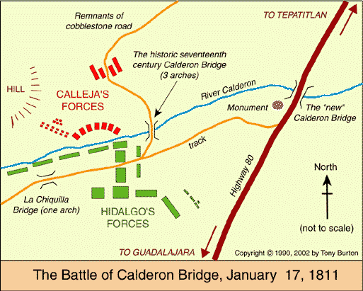
Curiously, the historically-accepted plan of the battle, reproduced in dozens of scholarly works and hung on display in many museums around the country (still including, to the best of my knowledge, the Regional Museum in Guadalajara) is in fact, upside down! And this despite the fact that the true orientation of the map was proven (way “beyond any reasonable doubt”) by Alma Rosa Barcenas. Her brilliant and clearly written article, appearing in the first number of “Geografía”, published by INEGI in Mexico City in 1986, clears up the confusion surrounding the exact battlesite.
The article presents a convincing argument, fully supported by both field-work and by aerial photographs, as well as by a minute analysis of contemporary battle descriptions which give clues to terrain, slopes and visibillity, that the map was drawn “south-upwards”. The map, as usually reproduced, does actually have a north arrow, but it points south!
Why, then, do many museums still have the map upside down? Presumably because they have not yet seen or read the article, though it must be said that a copy was supplied to the Guadalajara Museum (by yours truly) as long ago as 1988.
Here, reproduced on the Internet for the first time, is the battlesite plan the right way round. At last, the battle descriptions make sense! Now, anyone visiting the battlesite has a chance to work out for themselves the true dispositions of the troops on both sides, and of course of reliving, if only in their imaginations, the course of the battle…
Getting There:
Leave Guadalajara, going east past the new bus station (the Mexico City highway). Near Zapotlanejo , take the Tepatitlán/Lagos de Moreno turn, but make sure you stay on the “free” highway not the toll road. The Calderon Bridge is about 8 kilometers (5 miles) north-east of Zapotlanejo, 42 kilometers (25 miles) from Guadalajara. If you decide to visit the site, be prepared for spiky acacia bushes, mesquite plants and only limited shade; most of the shade that does exist is provided by specimens of the distinctive morning-glory tree.
Copyright 2002 by Tony Burton. All rights reserved.