
Cabo Corrientes is one of those vaguely heard of places where nobody ever goes because… well, where is it? And how and why would you go there?
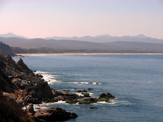
Literally, Cabo Corrientes means “cape currents.” It’s the point about 30 miles west of Puerto Vallarta where Banderas Bay finally gives up its apparent attempt to swallow the Pacific. Look at the map — you’ll see that as the bay opens and yawns to the southwest, its lower prognathous jaw begins to fall away at the tiny coastal town of El Chimo.
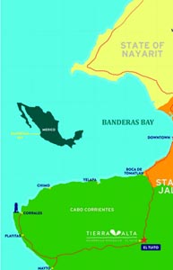
At the very end of the opening jaw is the cape with the old lighthouse. Both are called Cabo Corrientes, as is the municipality that includes about 75 kilometers of beautiful, empty and rarely visited beaches, beginning with the lower jaw of the Bay and ending along the Pacific coast as far south as the town of Villa del Mar. Yelapa is the exception, being the one beach town in Cabo Corrientes with a regular flow of tourists.
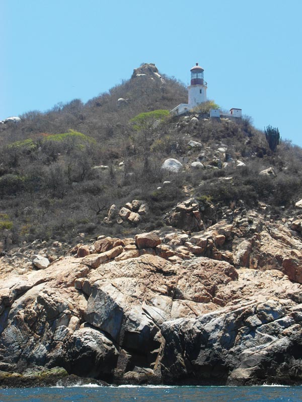
From Vallarta itself, you can’t quite ever see the last bay-defining point where the end of the bay is marked by the old lighthouse at Corrales. You can occasionally see that far end on a clear day from a vantage point on the opposing upper jaw at Punta Mita, whose residents are generally too happily distracted by golf to be much interested in aquatic geography.
But if you are moving west by boat along the lower bay past Yelapa and then past Chimo along the roadless coast toward the Pacific, you may technically still be in the bay, but you are now out of sight and out of mind. There is a kind of geographic and psychological tipping point. Ocean swells now rise and fall at their own remorseless rhythm, indifferent to your condition. At that point, it no longer looks or feels like a bay. You have lost its protection. And if you then round the cape and head south along the Cabo Corrientes shoreline, you can feel the profound difference between a defined bay and the open, endless Pacific domain. Now you are in Cabo Corrientes.
All bays, it turns out, are defined by their partial closure against winds and water. The Bay of Banderas is just such a protective zone: its orientation denies direct admission to most hurricanes. But it’s large and deep enough (maybe 3,000 feet in some places) to offer a complete oceanic environment with enough aquatic scale for humpback whales, giant manta rays, tuna, dolphins and marlin. There are times that Banderas Bay seems like a relatively safe theme park for seafarers who don’t really want to go to sea.
No, Banderas Bay seems to have been artfully designed for vacations and retirement. It seems to have been invented for people who believe they have suffered enough, so bring on the paradise, now, please. But as you leave the urban confines of Vallarta, the realities of tropical Mexico are always close at hand.
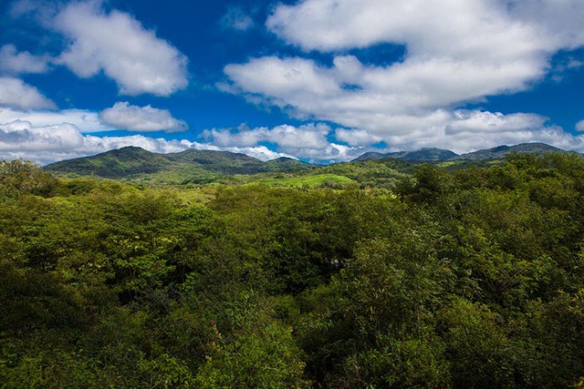
If you drive 25 minutes west from Vallarta along coastal Highway 200, you will cross into the Cabo Corrientes municipality just past Boca de Tomatlan. The road abruptly leaves the coast, swings due south and inland toward the town of El Tuito in the Sierra Madre Mountains. The winding road climbs into the pine and oak forests and you will begin to notice that, by contrast to the dense human landscape of Vallarta, there is just a thin scattering of people in the clustered settlements along the road. You are in Cabo Corrientes.
A look at the lighthouse
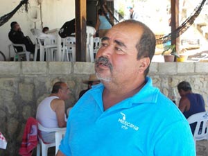
The current keeper of the old lighthouse at the very end of Banderas Bay on Cabo Corrientes is a man named Hector Hernandez. He says it’s true what we had heard, that the lighthouse was powered for decades by fuel carried by donkeys up the 200 meters of steep elevation. But now, it shines out stronger than ever in its 110 years of service. As Hector notes, the faro was built during the last days of the Porfirio Diaz regime. Today, it beams into the night from a battery storage system powered by solar panels. Hector says the light can be seen 30 miles away.
The place where no one’s there
Given the remarkable technological advance at the lighthouse, it’s a little strange that there isn’t a real gas station within 30 miles of Corrales, the tiny lighthouse town which relies on El Tuito for its supplies. And in fact, at the time of this writing, there was still no functioning gas station in El Tuito after 500 years as a trading town. Today it’s an attractive government center of some 4,000 people. The exterior walls of the old shops around the plaza are all painted with an ochre mix of local clays. A new gas station is finally scheduled for opening later this year, partly to fuel the vehicles which will be making their way on roads, soon to be fully paved, from El Tuito to the interior of Cabo Corrientes and then to the shores that very few people have seen.
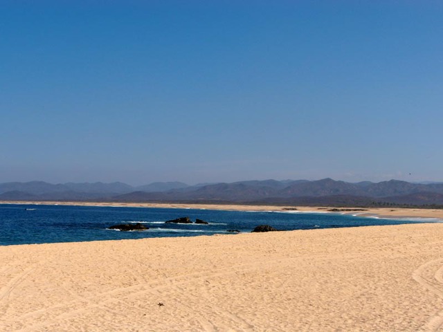
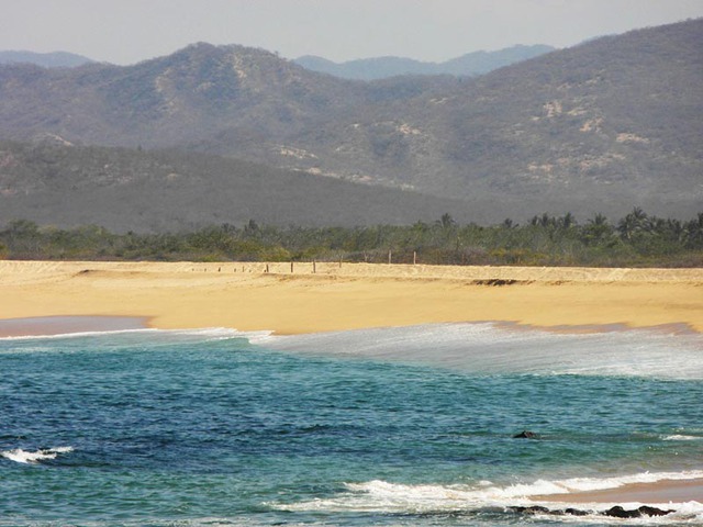
Cabo Corrientes and its open Pacific coastline have formed wide, sweeping, scalloped beaches that are more temperamental than Vallarta’s grand old bay. In fact, many of the beaches along the Cabo Corrientes coast are easier to reach by car than by boat. But if you know the simple, common sense driving routes that take you from El Tuito through the rugged mountain landscape of Cabo Corrientes, you can arrive at a world of wild, untouched beaches that seem quite unrelated to the domesticated waters of Banderas Bay.
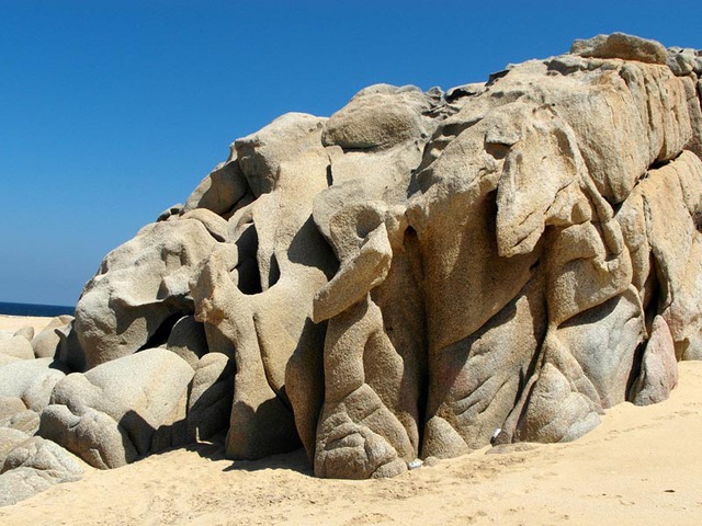
When you first reach many of these beaches, something seems missing. Then you note that there is not a single palm tree in view. Instead, there is a Sahara of rolling sand dunes and a few crossing places that bring you to the shifting dunes and back to terra firma. Returning to more stable inland soil, you will see a scattering of houses roughed out long ago. One of their measures of age is the ancient, tree sized bougainvilleas still cared for by the residents after generations. The plants shout out their defiant colors in the sun.
Cabo Corrientes is not a land of ease. How people survive here, well, it´s a question that seems to have something to do with how few of them there are.
To get to Cabo Corrientes
The town of El Tuito serves as the jumping off point, the hub in the wheel for reaching all of the untamed Pacific beaches of Cabo Corrientes.
Once in El Tuito, it’s your choice for a destination: Mayto? Tehuamixtle? Corrales? Villa del Mar? There are a dozen or more such towns along this nearly empty coast, each more windblown, more sun struck and less self-conscious than the last.
Of course, there are none of the Vallarta-style Margaritaville beach installations that may warmly recall your misspent youth on the beaches of the hotel zone on Banderas Bay. But there are friendly outposts along Cabo Corrientes — familiar old handmade restaurants on the water serving cold beer and superb seafood. Red snapper with garlic, oysters, lobster. And now there are a few modest hotels scattered among these miniscule beach towns. It’s not all austerity and rip tides in Cabo Corrientes.
But when you walk on one of these incredible broad beaches, alone, you will question whether humanity might have recently moved on to some even more impossibly beautiful and remote location. At times, there just seems to be no one there. The occasional lone fisherman sorting through his nets at the edge of the surf. A man placidly riding a horse. Two men doing something to a truck engine.
In the somnolent hamlet of Naranjitos (population 94), a woman saw us stopped along a dirt road near the water. She then also stopped her car, kids in the back seat, because she assumed, smiling warmly as she called out to us, that we were lost. She wanted to offer us directions to somewhere. In her view, being lost was the only possible reason for our being there.
It turns out that there really is almost no one there.
Measuring absence
Cabo Corrientes covers more than 2,000 square kilometers. It seems much too large to be a “municipality” (which in Mexico are entities that function like counties with a measure of independent governance). Puerto Vallarta is also a “municipio,” but it has only two-thirds the area of its municipal neighbor, Cabo Corrientes, to the southwest.
But Cabo Corrientes has a population of only 9,000 people scattered over its entire 2,000 square kilometers, at a density of 4.5 persons per square kilometer. The smaller Vallarta municipality (1,300 square kms) now has more than 350,000 residents for a density of about 269 persons per square kilometer, or about 60 times the population density of its larger neighbor, Cabo Corrientes.
This contrast in population is roughly equivalent to matching Connecticut (density 286) with South Dakota (density 4) as if they were right next door. That is a density contrast rare anywhere in the world but it’s a striking experience when you round the bend for the south on the coastal road at Boca de Tomatlan and head toward El Tuito. It’s equivalent to leaving the Bay of Banderas for the open sea. Take that southbound turn and, as you enter Cabo Corrientes, you are almost immediately in a population density of low single digits, close to Mongolia which may be the lowest density country on earth. Mongolia has only two people per square kilometer compared to 4.5 in Cabo Corrientes. This compares to a density of 31 in the U.S. (all those wide open spaces of the West) and Mexico itself at 57.
Population densities
Despite my preference for low populations, I think we all harbor a faint anxiety about places with very few people. It is perhaps rooted in our need for security through a sense of community.
For some, the absence of people may weaken our aesthetic response to places with scant signs of human presence. I may be attracted to the empty spaces in the world. But there are obviously millions and perhaps billions of people whose preference is for a dense coating of humanity — a kind of Coney Island of concentrated humanity.
Back in Vallarta, the humpback whales don’t seem to mind the inter-species density in the shared use of the Bay each winter. A constant trail of tourist boats follows the whales’ unlikely public mission: to calve and to mate under the steady close-up gaze of tourists with cameras. We must hope that such density can be tolerated without damage to the whales’ sense of privacy.
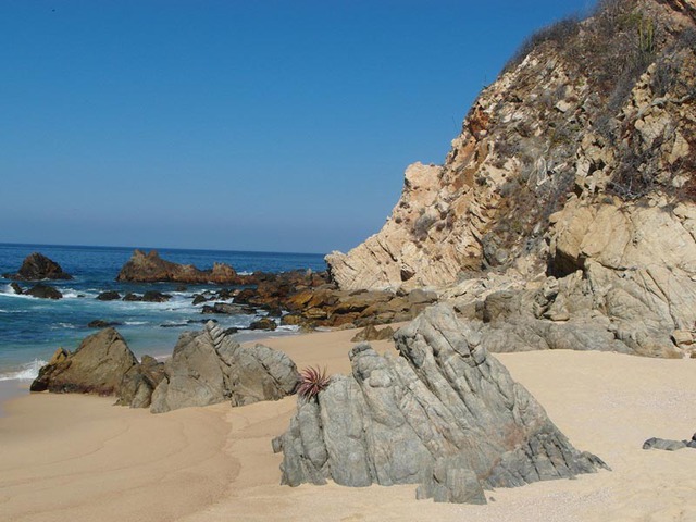
On the shores of Cabo Corrientes, the density challenge at times seems to have been solved by replacing people with wonderfully sculpted rocks. At Playitas, there are water-cut stone menageries that look like a stampede of vaguely African imaginary animals, suddenly frozen just before reaching the surf.
By contrast, Banderas Bay seems to carry on the romantic dream that the bay somehow cares about the people who line its gorgeous postcard shores, all set about with coconut palms. Cabo Corrientes, on the other hand, is an environment that does not seem to even notice us much. Cabo Corrientes still seems distracted by its own more desolate beauty, perhaps because it is simply not accustomed to being seen by anyone at all.
The Mexican Tourism Board on Cabo Corrientes |
| Along the coast of Cabo Corrientes, around 75 kilometers in length, you’ll find a set of paradisiacal beaches of fine, white sand, abundant vegetation and spectacular cliffs. Some of these beaches have barely been explored, making them ideal for those seeking to go deeper into the wilds of the Mexican coast and forget the noise and pollution of the cities. A great variety of fruits are grown in the fertile soil of Cabo Corrientes: mangoes, papayas, banana and coconuts are the main crop, and a number of enticing local dishes are prepared using them. |
Mountain fastness, beach retreats
We have lived for more than a dozen years on the “inside” of the big bay of Puerto Vallarta. But now my wife, Xochitl, and I plan to live on the outside, curled up in a cabin we will build in an old oak forest right on the edge of the town of El Tuito. Yes, there are other bays waiting along the rough coast of Cabo Corriente,s and some are just a half hour or so beyond El Tuito. Visiting these “new” beaches and bays will soon become regular excursions. But they will only be excursions — we will not live on the coast, mainly because we want the variety and ease of access to all of the coastal destinations of Cabo Corrientes, soon to be paved and possible from El Tuito.
At this point, the roads can be rough, especially in the summer rainy season. At times, you can still be punished by washboard road surfaces on your way to the blue bays ahead. Through the miracle of new infrastructure, however, the time to reach any of these beautifully desolate beaches will soon be magically abbreviated. The passable 44 km road from El Tuito to the Mayto coastal area, for example, will be comfortably paved by the end of 2015. (Until completion, caution is advised in the June through October rainy season). Beach drives from El Tuito will steadily become easier, faster, safer and cheaper.
The largest infrastructure undertaking in Cabo Corrientes is not the new paved highways but the Presa de Los Panales, an enormous new dam and irrigation now under construction close to the center of the municipality and due for completion in 2014. It will gather and disburse water to areas along the entire Pacific Coast of Cabo Corrientes, for use in agricultural and also for tourism projects. There will be a better life for the few people living in this sparse stretch of parched land. The population “drought” will at least be partially resolved by new arrivals responding to the economics of access to an excellent water supply for the first time in the human history of Cabo Corrientes.
This new water source and the new roads may eventually bring more people than I would like to the coast of Cabo Corrientes. But if the whales can bear the density of sharing their bay with tourists from Ohio, I must happily accept more than Mongolian densities along this stretch of untouched beaches.
Tierra Alta
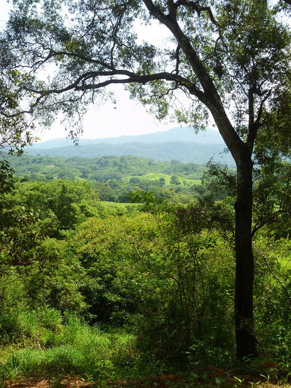
Returning from the coast to El Tuito, we are welcomed by country roads that radiate from town with predictable irregularity and are perfect for an afternoon ramble. Our country landscape has a more human scale than the empty coast of the municipality.
Our land is defined by the foothills of the Sierra Madre, the mountains that form the north-south double spine of Mexico. In our own small settlement, called Tierra Alta, just outside El Tuito, the population will be at a density low enough to make this important difference: we will welcome rather than resent the sight of another human being.
This eco-project for cabin sites is located just outside of El Tuito. The intent is to “develop” as little as possible of Tierra Alta, instead, enjoying this beautiful forest with minimal disruption. True, there will eventually be a shared swimming pool among the venerable oaks. There will also be a full complement of modern amenities such as satellite TV, high speed internet, cell phone and land line service, any of which were unimaginable just a few years ago. There is now a clinic in El Tuito and there is now at least one doctor offering 24/7 emergency medical services in El Tuito.
Something like 35 percent of the Tierra Alta property goes to access roads, green spaces and land donations to the municipality, which runs a reforestation program. Maybe there will be 20 cabins at Tierra Alta. But that seems like an appropriate density of kindred spirits at this time in life.
Local Mexican food food? The best
There are very good restaurants in El Tuito with wonderfully flavored local food including mariscos (seafood) fresh from the coast of Cabo Corrientes. By this time, if you still reside along those welcoming shores of Banderas Bay, you may be nervously fingering your Vallarta restaurant guide in search of a more familiar dining experience than seems likely in the hinterlands of Cabo Corrientes. Maybe you’re considering one of those classic Vallarta dishes from Charlie’s Wok that comforted John Huston when he was living inside the Bay.
But rest assured that El Tuito dining adventures abound.
There is Mario’s right on the central plaza with excellent local dishes such as chicken in pipian (almonds, squash seeds, sesame seeds, chile ancho, cinnamon y cloves). Or you can enjoy a 15 minute drive to a beautiful country inn called Divisadero, where you can be very well served while tasting the local variety of raicilla (a close relative of tequila). Or try the Mojarra Restaurant, an unlikely low profile, open air truck stop across the from the soon to be opened gas station. Enjoy a plate of very spicy, bright red shrimp called, with a straight face, cucarachas.
Why choose El Tuito?
So for us, trips to the great Banderas Bay will often be replaced by frequent visits to the many bays and beaches along the Cabo Corrientes shore. Tierra Alta will remain a small settlement of like-minded cabin dwellers in the oak woods with a tendency to head off to the coast on a whim. The people we will meet along that coast will be very friendly but often, like the woman in Naranjitos, they will be a little confused about why we are there.
In part it’s the weather. The weather in the mountains of Cabo Corrientes is as close to perfection as can be imagined. Vallarta has nearly perfect weather, but El Tuito is noticeably cooler and drier in the summers at an elevation of 2,000 feet. For me, life in the mountains of El Tuito often feels like having just awakened from a cool late morning siesta. My dreams seem restored by the energy and curiosity of a deliberate retreat from a predictable retirement on the big protective Bay. How fortunate it is that our life in the mountains and on the beaches of Cabo Corrientes is not an appropriate life for most people. The population will grow, of course, with the new roads to the empty beautiful coast and the new source of water. But there will be no rush about it. Not here, not in this country and not in our time.
We are certainly going to “keep” Puerto Vallarta, that glorious tropical swoon of a town just an hour away from our new home in the mountains. Our friends and our spoiled urban habits will always bring us back. And our friends and family will come to see us in the mountains where they will join us on the beautiful, empty beaches where we will just slightly raise the density for a morning or an afternoon.
There will be few reasons for nostalgia. Tierra Alta seems like the right place for a late chapter, an early siesta in the cabaña and tomorrow another beach just down the coast that we’ve never seen before.
A very enjoyable read. I love El Tuito. Great coffee. I look forward to spending more time in El Tuito. I’m absolutely enamored with Tehuamixtle! Simply the finest oysters I have ever had in my life. Gorgeous little spot. The turtle release in Mayto is very wonderful. I have the faro on my list and further exploration throughout Cabo Corrientes. Appreciate your sharing and writing.
I fear South of Tehaumixtle is the next big development. Maybe North from Tehua to Pizota will be spared. All good.
Salud