Clickable interactive map of Michoacán, Mexico: Morelia, Uruapan, Patzcuaro, Zitacuaro, Playa Azul, Zamora, Paricutin volcano
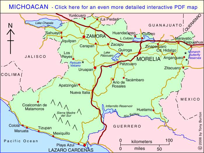
The state of Michoacán is in the Central Pacific region, along with the states of Jalisco, Nayarit and Colima. Michoacán is one of the most diverse states in Mexico in terms of its people, landscapes and economy.
The state of Michoacán has an area of about 58,600 square kilometers and a population of about 4.6 million (2017). The capital city of the state is Morelia, a university city with an abundance of beautiful colonial architecture. Other important cities include Zamora, center of an extensive agricultural area that specializes in strawberries, and Lázaro Cárdenas, site of a major oil refinery and container port.
The coastal scenery of Michoacán is among the finest anywhere in Mexico. Inland, volcanic peaks, such as Paricutin Volcano, vie for your attention with fertile intermontane valleys. The state is famous for its celebrations of cultural traditions such as Day of the Dead. Tourist “Magic Towns” in the state of Michoacán include Pátzcuaro, Tlalpujahua, Cuitzeo, Santa Clara del Cobre, Angangueo, Tacámbaro, Jiquilpan and Tzintzuntzan.
This state is the heartland of the indigenous Purépecha people, whose language and customs have remained largely intact to this day.
Clickable interactive map by Tony Burton
Published or Updated on January 1, 2005 by Tony Burton.
This interactive map of Michoacan, Mexico, is absolutely fascinating! 🗺️ I love how it allows us to explore the region’s rich cultural heritage, breathtaking natural landscapes, and vibrant cities. It’s like taking a virtual journey through Michoacan from the comfort of our own homes. 🌄🌺 The level of detail and interactivity truly brings the map to life. I can’t wait to plan my next trip to Michoacan using this incredible resource. Thank you for sharing this gem! ✨🙌
Hello, I’m running a one man non-profit documenting the decline of Lake Patzcuaro and the culture it has fostered for centuries. I am requesting permission to use images taken from this map as part of my work. If you are willing please email me and I’ll share the work in progress that I’ve put a great deal of effort and money into with absolutely zero support from local authorities or individuals in Pátzcuaro. I would greatly appreciate and acknowledge your work as you choose the statement to be phrased. My project is meant to be sent internationally and thus is in 5 languages, I will attribute you in each one of them. Beautiful and amazing work you’ve done, I hope we can connect. I’ve sacrificed far too much for something that will never produce a dime for me but will hopefully call international attention to the maltrato del Lago Pátzcuaro. Me puedes hablar en Español si prefieres. Gracias.
Response sent via email