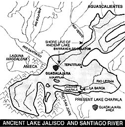
The following is a story concerning an ancient lake that covered a large area of the State of Jalisco and spread into Michoacan and Aguascalientes. This map is a visual portrayal of the lake superimposed on a regional map.
The south central portion of the State of Jalisco presents a panorama of lakes arranged in the form of a right angle, with one leg oriented east-west and the other north-south. Starting with the largest lake in the east they are: Chapala, Cajititlan and El Molino: then turning abruptly south are Atotonilco, Zacoalco, San Marcos, Atoyac, Sayula and Zapotlan. All of these lakes range from shallow to dry. For instance, Chapala has a mean depth of twenty-nine feet, whereas other lakes, such as San Marcos, are covered by water only during the wet season of the year.
Having studied a similar series of lake basins in eastern California, I came to the conclusion that probably at one time all of these lakes were connected by drowning of the low divides separating them, forming one huge lake. If such a lake did occur in the geological past there must be evidence to prove its existence.
Such proof would include stratified deposits of lake sediments, wave cut terraces and deep gorges of rivers that drained the lake basin. I attempted to research any work that had been done on this particular theory and discovered that Mr. George Mitchell, in collaboration with several other people, had done considerable work on this very same idea. I pursued their work and in addition attempted to verify some concepts of my own.
In an attempt to visualize the sequence of events that portray the history of such an ancient geological episode, let us imagine this ancient landscape in late Pleistocene time, approximately 38 to 40,000 years ago. Fossil evidence indicates ancestral mammoths, mastodons, camels and horses roamed the area before the basins were filled by waters of the lake. The landscape at night was illuminated by the glow of scores of volcanoes in a zone approximately 150 miles wide.
This belt is known as the Sierra Volcánica Transversal, and crosses Mexico between the 19th and 21st parallels of latitude. For 10,000,000 years during the Miocene, Pliocene and Pleistocene epochs this area was a fiery inferno of constant volcanic activity and magnificent giants such as the Grizaba, La Malinche, Iztaccihuatl, Popocatepetl, Volcan de Toluca and Volcan de Colima, along with thousands of smaller volcanic cones, came into eruptive existence.
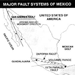
An explanation of this phenomenon might be in order; North America north of the 21st parallel is moving east, and south of the 19th parallel it is moving west. The zone between these two master fault zones, the Zapopan (north) and Clarion or 19th (south) are being distorted by these two counter movements with the crust being broken down into a series of massive blocks varying in elevation.
Along these fractures huge volumes of basaltic and andesitic lava are being extruded on the surface to form the volcanoes that separate the plateau into a series of basins, ei. the Jalisco basin, which also contains a series of smaller basins such as the Atemajac Valley, in which Guadalajara is located.
Drainage of these basins has been generally accomplished by some major river or rivers. Specifically, the drainage of the huge Jalisco basin was accomplished by essentially the same rivers that drain it today, namely the Santiago-Verde in the north, the Ameca in the west and the Tuxpan and Armeria in the south. All of these rivers flow through thick layers of volcanic debris that is of recent origin, deposited by volcanoes that were active or still are.
These volcanoes are located on the fracture zones mentioned previously. According to field evidence, volcanic activity occurred along the Zapopan fault zone in the north, forming La Higuera, El Mexico and La Campana volcanoes, thus filling the Santiago-Verde channel with thick lava flows interbedded with explosive fragmental material.
In the south, blockage of the courses of the Armeria and Tuxpan rivers was accomplished by the Colima volcanoes, which occur on the 19th parallel fault, one of the most active in mexico. The America channel was filled by volcanism in the Sierra de la Venta mountain rage, specifically the Colli and Popoco volcanoes, which is adjacent to the Pacific fault that parallels the coast.
In the previously mentioned areas there is ample activity at the present time: boiling springs, fumaroles (steam vents), geysers and actual eruption of the Volcan de Colima.
The above closures started the impoundment of the water which was supplied by the ancestral rivers. Climatological evidence implies very heavy precipatition for this epoch of earth history. When maximum capacity of the basin was achieved, which probably took at least 30,000 years, this huge inland sea covered 8500 square miles, a little over one fifth of the present state of Jalisco, and extended from a point south of the present city of Aguascalientes on the Verde river to the north, La Piedad de Cabadas on the Lerma river to the east, La Venta Primavera to the west and Ciudad Tuxpan to the south.
The average depth computed from terraces was 820 feet. The Guadalajara area of the Atemajac Valley was covered by 690 feet of water.
Drainage occurred as a result of faulting along the Zapopan fault system that previously supplied the conduit for transfer of molten material that filled the valley. Along this fracture zone occurring at the base of the La Higuera and El Mexico volcanoes, the Santiago River has cut a fantastic gorge known as the Barranca de Oblatos, which may be admired from the Mirador (Scenic Viewpoint Park) Dr. Atl in Guadalajara.
The barranca is 2000 feet deep and is cut in layers of resistant basaltic lava flows and softer explosive fragmental material. Proof of the faulted nature of the channel may be appreciated by trying to match layers of rock on both sides of the gorge; they do not align, thus proving displacement by faulting.
Working within a time period of 38,000 years, the erosion of this gorge by the Santiago-Verde was accomplished in a period of approximately 5000 years plus or minus – a remarkably short time. The giant lake supplied a terrific hydraulic potential to the rivers draining it. The water volumes and velocities attained by the rivers must have been fantastic.
Imagine standing on the rim of the Barranca de Oblatos and observing the spectacle of this mighty river roaring through the canyon below, carving the tremendous gorge! This same history was repeated int he gorges of the Ameca, Armeria and Tuxpan rivers.
Evidence indicates that drainage of the basin was not uniform but seemed to be in stages, with the lake level attaining stability for very long periods of time, with wave action creating terraces, similar to the beach at the sea shore. Throughout the area four main terraces were cut by this wave action. There are three options open to persons attempting to account for these periods of lake level constancy.
Primarily, there is a strong possibility that the lake terraces may be correlated with terraces developed in the barrancas by the rivers. As stated previously, the volcanic deposits in the barrancas are an inter layering of explosive deposits and lava flows; the explosive material is poorly consolidated, resulting in rapid erosion and would account for the steep slopes between the lake terraces, signifying a rapid drop in both lake level and barranca depth.
On the other hand, lava flows are highly resistant and erode very slowly. Consequently the lake level would drop very slowly and the terrace would develop. Secondly, there could have been alternate periods of heavy and light precipatition in which a balance could have been established between a lake intake and discharge. Finally, periods or renewed volcanic activity along one or more of the discharge channels could temporarily block the discharge and create a terrace.
The stratified lake deposits are visible throughout the area covered by the lake. These distinctive banded layers are exposed in countless numbers of locations, and can be observed where the cuts were made for the Guadalajara-Chapala highway, and for the Ajijic bypass of the same highway. The terraces which occur as sloping benches cut by the wave action are very prominent at Chapala.
The lakeside communities are located on the lower terrace and the three subsequent ones are visible on the slopes of the mountains behind. If one takes a trip to Tapalpa, the highway ascends steeply, and then levels off on the multiple terraces, offering a magnificent view of the dry lake beds spread out below.
The age of the lake has been established by means of Carbon 14 dating of wood samples encountered in the sediments. These specimens indicate an age of 38,000 years, establishing the lake as occurring in late Pleistocene time, a geological epoch that spanned 1,000,000 to 25,000 years ago.
This remarkable division of time in Earth history noted primarily for four great glacial invasions of ice in the northern hemisphere, advanced as far south as St. Louis in North America and Berlin in Europe. Most of the mountain systems were covered by ice which eventually melted to form many large lakes on the continents affected. Great Salt lake in the state of Utah is a descendant of glacial Lake Bonneville which covered 19,000 square miles and was fed by glaciation in the Wasatch Mountains.
Naturally, Lake Jalisco was not fed by glaciers but, like the rest of the northern hemisphere, the precipitation was very much greater than at the present. Diatomaceous earth deposits found throughout the area imply a cool climate which would be in keeping with the extremely frigid conditions that existed in North America.
As mentioned before, the largest remnant of Lake Jalisco is Lake Chapala, with only a very small area of 825 square miles compared to its predecessor’s 8500 square miles. A tremendous reduction in area and volume has taken place, due to ruptures on the basin walls and eventual drainage.
Can the future of Lake Jalisco be predicted? All lakes are subject to the same fate: they are doomed as soon as they come into existence. A lake basin is a natural depression for deposits, and given enough time will be filled by sediments carried into it by streams and rivers, plus the material washed in by drainage of the slopes surrounding it.
We have come to the end of one chapter in the life of a lake and the rivers that drained it. Will these rivers continue in their erosion and eventual destruction of the plateau, or will volcanic activity restore the lake and plateau? Quíen sabe?
(Jack Leyden, the author of this article, was Professor of Geology at the University of California. Before his passing away several years ago, he was active in the American community in Guadalajara.)
- For an updated map of “Lake Jalisco”: “How big is Lake Chapala?”
This article originally appeared in “Mexico Living and Travel Update”, Fall 1994,
and is presented here with their kind permission.
You mention that the various lake terraces can be easily seen around the Chapala area. Can you say where might be any good spots to view these?
Alan, Unfortunately, Professor Leyden is no longer with us, but his suggestion of looking for the terraces as you drive from the “dry lakes area” (near Sayula) up to Tapalpa, is a good place to start.