“It is well to leave some water in your neighborhood, to give buoyancy to and float the earth.” (Thoreau, Walden Pond, 1845)
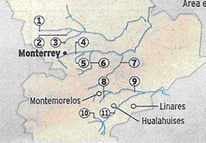
Note: Following are my comments based on a report published by El Norte. A reporter (Armando Estrop) visited seven rivers and two arroyos in different municipalities surrounding the city of Monterrey, (alt. 53.3 m.) (pop. 3 million), Nuevo Leon, Mexico ( look at the map) during a period of four months and reported what he saw.
According to the reporter doing the story (article: El Norte, “Corren por ríos de NL contaminación y olvido,” Monterrey, June 23, 2002) the rivers and arroyos of Nuevo Leon have greatly increased levels not of water but of garbage.
He observed first hand plastic throwaways, cans, garbage and even dead animals that had accumulated in the little rivers. What follows is my interpretation of what the reporter saw mixed with my experience, knowledge and love for some of the rivers of Nuevo Leon.
The reporter says the rivers or what’s left of them are all badly contaminated. He said mountains of trash, various kinds of sanitary and unsanitary refuse, almost anything imaginable–choke the little streams of water that usually run in the semi-arid regions of the area at this time of the year. I have to agree with him.
Monterrey has two sides, wet and dry. The dry side is north and extends east and west. The dry side extends in a kind of arc from Saltillo in the west to the road to McAllen, TX going north and east from Monterrey on the right. Some of the rivers in the report are located here. On Monterrey’s other side is the Gulf side, it is the Cumbres or Summits side and it is the green or wet side.
Some of the rivers identified are located here. (Río Ramos, for example) Anyway, Nuevo Leon and Monterrey’s geography has a lot to do with the state or condition of the rivers surrounding the metropolitan area. Exploding population and migrants arriving from the countryside in exponential numbers also impact natural waterways. Migrants from the mountains polluted their streams and rivers, so when they migrate to Monterrey the streams get the same abuse. This destructive ecological-social norm is passed down from generation to generation.
The mountains on the east side of the city of Monterrey are not as abused, in my opinion, as the rivers on the dry side. For one, there’s more water on the wet side. Also, the mountains, the Cumbres (mountain range) act as a kind of buffer zone, soaking off the moisture carried inland from the Gulf before it reaches Monterrey. Going east to west, Monterrey is really the beginning point of the drier region in this part of northern Mexico, but it is not all dry.
There are rivers, at certain times and seasons-on the green side of Monterrey during the spring and fall rainy seasons-when otherwise sluggish puddles meandering a dried out water course rear up and take off like a Colorado mountain stream, transformed into the perfect white water for a sport kayak. Paddling Río Ramos from Matacannes to Allende, Nuevo Leon is very possible during the rivers high water mark during the rainy times.
The trick is in the timing. One would have to have all equipment at the jump-off site at the right moment when the rains start. The mountain run-off builds momentum and I have seen Río Ramos (number 6 on the chart) turn into a brown raging torrent, perfect waves for canoeing, rafting, tubing or kayaking. The roads during these times are practically impassable.
When it rains, the watery run-off has a salutary effect on all the streams and rivers of the area. The running water, if there is enough, carries away all the accumulation of flotsam and jetsam thrown aside by Mexican tourists and residents, including beer and soda cans, lots of Styrofoam plates and glasses, bags of refuse, dead animals and even baby diapers.
So, it isn’t a good idea to jump off into a river current when the water is loaded with junk. Wait until it rains for a while, say a day and a night, with signs of continuing, before you launch. Río Ramos, to my knowledge has never been ridden from above Las Adjuntas to Allende. Río Ramos at Las Adjuntas is also one of the few sites where garbage barrels are in place and regularly emptied.
In Nuevo Leon, typical rivers become refuse dumps. Then it rains and floods and everything is clean again. This is the launch window. Be prepared to camp for a day and wait for more bad weather to raise the level of water in the river so you can float (fly) downstream. After the storm people start visiting again and the campsites are littered again. The cycle repeats itself. I don’t know if anyone has done a study to see where all the rubbish from Nuevo Leon’s waterways ends up? I know the dirty baby diaper dropped into Río Ramos in the vicinity of Las Adjuntas (alt. 720 m.) will with a little luck reach Allende (alt. 520 m.) located downstream about 25 miles.
The people of Allende (pop. 5,000) in their turn use the river for bathing, drinking, irrigating pesticide protected fruit orchards, and the river is used for carrying away their disposables to the next village downstream. Along the way, with each fresh chemical discharge into the mountain stream there is a corresponding degradation of the water.
Recently Bush aids sarcastically remarked that pollution causing degradation of river water actually helped protect the fish in contaminated waters because no one wants to eat that kind of fish. The logic?–contaminated fish have a better chance of surviving because fewer of them will be eaten by fishermen. The statement ignores the deadly effects of chemicals and sludge dumped into the water on the food chain, not just fish. What happens if someone accidentally eats one of the “protected” fish in the Bush example?
The Army Corps of Engineers, according to a recent article in the New York Times, apparently with Bush’s blessing has a federal government permit that allows it to annually dump 50 tons of waste sludge into the Potomac River, which runs through Washington, D.C.!!
Río Ramos is not the Potomac. It is located in Nuevo Leon, not far from where Monterrey, (alt.53.3 m.) Mexico is located. Too reach Río Ramos turn off the national highway at El Cercado, (alt.535 m.) N.L. Then drive up to Puerto Genovevo (alt. 1,085 m.). Turn left and drive the 10 kilometers on the old logging road to Las Adjuntas (alt.720 m.). Follow the old logging road to Portrero Redondo (alt.1,305 m.) and on to La Trinidad (alt. 1,400 m.) for an unforgettable 4×4 or hiking experience. This is a very scenic route, ideal for hiking and camping, rock climbing, and mountain bicycle touring.
Here the air and water is pristine and beautiful. Fresh breezes carry the scent of pine and the water in Río Ramos. The water above Las Adjuntas is the color of rare green turquoise. During the camping, hiking, mountain biking, 4x4ing, family picnic season –you might say tourist season in this section of Cumbres National Park–the garbage tends to pile up in frequently visited camp sights along the river. Don’t let this deter you.
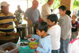
Sometimes the garbage is cleaned up by the campers themselves, who arrive–have to clean the campsite before they can stay there–camp, clean-up so the next group starts with a clean campsite. The next group, instead of cleaning-up, leaves the campsite dirty again, and the cycle repeats. The campsite is degraded and so is the nearby river.
In Mexican cities people have a tendency to throw their garbage, pop cans, plastic bags, litter of all kinds, into the street. It is no different in the countryside or wilderness areas. There is a lot of garbage out there to ruin the aesthetic look of wilderness and natural places. When visitors come to visit Cumbres National Park, in Nuevo Leon, they have to put on a kind of metaphorical pair of lens that filters out all the litter. If you don’t, if you look at the litter–not at what’s behind the litter–you won’t enjoy your trip.
Summary of the El Norte report on Monterrey’s rivers.*
* These are the descriptions from El Norte of the many abused rivers in and around the city of Monterrey. The report was published by El Norte, Sunday June 23, 2002.
Río Pesqueria ( #1, on the map) serves as a garbage catchments basin, trash all along the shore filling the area next to the temporary housing and a pigsty. The discharge of sanitary drain here changes the color of the water. A good idea is to avoid contact with the water here. El Norte reported that in the Pesqueria municipality where the river interfaces with a community called Zacatequitas, on the way to Agua Fria, lots of garbage has accumulated on the riverbanks and lots of drain discharge is found along the way.
Allende (Via Santiago). Upstream Río Ramos (6) about 25 miles you come to the junction with Río Mauricio. Río Mauricio is sleeping most of the year, but with some good rainstorms comes to life and is a delightful watercourse to follow. Barrels full of trash and no one to empty them are common in Las Adjuntas. Some of this trash floats down to Allende where they drink the water. To clean up the river in Allende the work has to start upstream where Río Ramos and Río Mauricio meet at Las Adjuntas, Via Santiago, N.L.
There is little water in Río Hualauhises. (10) A gray residue clogs what flowing water there is.
In Guadalupe there is Río La Silla. (5) People still wash their clothes on the rocks. Very picturesque and lots of soapsuds enter the water system here. The river flows past a temporary housing complex made up of zinc lamina, cardboard and wooden boxes. The community is called “La Joya” (the jewel). People here dump used oil into the river.
In Linares-Teran there is Río Conchos. (8) The little water there is collected in stagnant pools among the rocks. The contaminated pools breed mosquitoes by the thousands.
Another river visited was Cabezones, (9) which separates the territorial boundaries of the Linares and Montemorelos municipalities. One of the main problems reported here was the simple lack of water. The same problem was found in Hualahuises, (10) located in a municipality by the same name, garbage in the river yes, water in the river course no.
In Monterrey there is Arroyo Topo Chico (3) described as a garbage dump filled to over flowing in Colonia Topo Chico. What does the state tourism authority say about it? El Norte pointed out that in Arroyo Topo Chico the problem is getting worse because lots of the garbage that Monterrey has ends up here. The river continues accumulating a great quantity of paper, plastic throwaways and even tires, which one can see looking down from the bridge in Colonia Topo Chico.
Linares has Río Pablillos. (11) There are houses in the creek bed where everybody throws their garbage. Just under the bridge located there is a favorite spot for residents to toss all kinds of refuse. There is a kind of settlement established there and the people there have horses, dogs and other domestic animals. El Norte reported there was a lot of garbage here and the human shelters had no running water, electricity, or sewer system. Every 20 meters there is a mountain of garbage, according to the reporter. People here are frequently sick with infections of the skin and intestines.
Río Santa Catarina (4) where it winds through La Huasteca Canyon area is full of makeshift housing. All these homes were washed away during the great Gilberto hurricane in Monterrey in 1988. Río Santa Catarina flows through Monterrey and Guadalupe when it has water. That sounds like a strange thing to say but is true. **I saw R161o Santa Catarina in “rip tide” during the hurricane Gilberto in 1988. At the location of Colonia January 21 El Norte reported 10 viviendas and garbage dumps along the shore.
Río Salinas (not shown) is located in Salinas Victoria. Garbage scattered everywhere but no water for the river in sight until the next rains come in the fall, or count on the rare summer storm to fill the streambed.
Observation.
Nuevo Leon is a great place for its natural tourist attractions like Parque Ecologico Chipinque, Horsetail Falls, and the magnificient Cumbres National Park. But, the rivers flowing through or passing nearby these places everywhere in the State of Nuevo Leon -in and around the City of Monterrey–are endangered.
No one is asking for the intrusive presence of police everywhere, like in the U.S., to stop people from littering natural places. What is needed is the immediate intercession of regular clean-up services. The clean-up crews create employment for local unemployed. In addition, certainly the government could sponsor some kind of public education campaign to ask citizens (students young and old) to properly dispose of their trash?
Not throwing litter in the rivers is one problem. During the rainy seasons when the flood waters are cleansing the state’s little streams and rivers…guess what’s happening in Monterrey’s city streets? You guessed it-massive flooding. During the recent rains the city and larger municipality drain systems, the one’s that flow into the area’s natural drainage system (the streams and rivers we have been talking about) become plugged with litter and garbage. The drains, too. Is this a surprise?
The rain is intense for a few hours then slacks off. But the downpour has no place to go. The drains are plugged. There is enough liquid to submerge even secondary streets and large avenues in giant black pools of excess rainwater. The flotsam and jetsam is everywhere, including Styrofoam objects, paper and soda cans, plastic garbage bags, the same litter clogging the area’s streams and rivers!
The flooded streets during an occasional thunderstorm cause mayham and panic. People stall their cars in water reaching up to the window. City buses roar past sending showers of water on pedestrians and other vehicles. Emergency city services like ambulance and police and fire trucks have to take detours around flooded streets to reach accidents and emergencies. Power transformers regularly get soaked in the heavy shower and explode. Entire neighborhood communities have their power grid suddenly shut down. The flooded streets complicate things during these times. Some panic, take risks, and some drown. There is litter and garbage floating everywhere.
Conclusion.
The problem of forget and contamination of Nuevo Leon’s natural streams and rivers, as reported in El Norte, is really part of a larger problem connected to the area’s municipal drainage system. Both the rivers and the drains are clogged with more and more garbage every year. The government, one, has to admit there is a garbage problem. When the streets flood there is a problem. But when there is no rain there are no flooded streets and therefore there is no problem. Out of sight out of mind. This mind set has to change. Beautiful natural rivers and a drain system that works have to be inculcated into the Mexican consciousness as an important national value. Somehow the idea of properly disposing of trash has to be shared by the Mexican public.
The government has to show leadership here, set a good example, and reward communities with clean rivers and drainage systems that work.

What is the name of the river at Marin, N. L., which which the dam and reservoir La Juventud (if I have the nae right) are formed?
Río Salinas, and YES, it is Presa de La Juventud.